


SityTrail - Cap Lardier,Cap Taillat par le col de Collebasse

affinetataille
User GUIDE
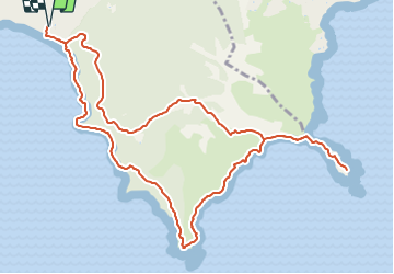

Length
13.6 km

Max alt
114 m

Uphill gradient
350 m
Km-Effort
18.2 km

Min alt
0 m

Downhill gradient
350 m
Boucle
Yes
Creation date :
2021-07-02 12:54:04.008
Updated on :
2021-07-29 12:15:36.716
4h30
Difficulty : Medium

FREE GPS app for hiking
 SityTrail
IGN / Geographical institutes
SityTrail Plus
The world is yours!
About
Trail Walking of 13.6 km to be discovered at Provence-Alpes-Côte d'Azur, Var, La Croix-Valmer. This trail is proposed by affinetataille.
Positioning
Country:
France
Region :
Provence-Alpes-Côte d'Azur
Department/Province :
Var
Municipality :
La Croix-Valmer
Location:
Unknown
Start:(Dec)
Start:(UTM)
304870 ; 4784222 (32T) N.
Comments
super